Jododaira &
Higashi-Azuma Area
-

Jododaira
Situated at an elevation of 1600m, Joudodaira presents an array of landscapes – from desolate mountainsides covered in volcanic gravel, to wetlands dotted with marshes and ponds, to fields of alpine flowers. Just one hour by car from Fukushima City, the visitor center, parking lots, mountain trails and nature sightseeing routes, and other facilities help you spend an enjoyable time in alpine nature at your leisure. At night, the star-filled sky makes Joudodaira one of the prime locations in Japan for night-sky observations. You can enjoy real astronomy at the telescope-equipped observatory.
-

Jododaira Visitor Center
This is the National Parks information center, located on Jododaira at an elevation of 1600 m, halfway up the Bandai-Azuma Skyline. The center uses dioramas and photograph panels to give easy-to-understand explanations of the natural history of the Azuma mountain range. The center also provides advice on mountain climbing, hiking, and nature observation, so it is recommended to pay a visit before setting out. Nature goods, books, and original mountain climbing memorial badges are for sale in the corner shop Mori-no-honyasan.
DATA
Opening hours 9:00 – 16:00
Winter closing Mid-November – Late April
Address: Washikurasanchinai, Tsuchiyuonsen-machi, Fukushima-shi, Fukushima-ken
Tel: 0242-64-2105 (closed during winter)
Fax: 024-591-3621 -

Mt. Azuma-Kofuji
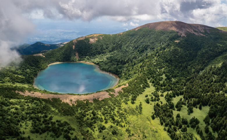
Millennia of volcanic activity has shaped the rugged landscape of the Azuma Mountain Range in Bandai-Asahi National Park, creating peaks like Mt. Azuma-Kofuji (1,707 m). The conical shape of the peak and its symmetrically sloping sides draw comparisons to Mt. Fuji. Kofuji means “Little Fuji.” A hike to the crater rim takes around 10 minutes from the Jododaira parking lot. The rim commands panoramas of the Fukushima Basin, the Jododaira Marsh, and views into the crater, which is approximately 70 meters deep and 500 meters in diameter. It takes around an hour to circumnavigate the rim.
-

Mt. Issaikyo
Steam and volcanic gases escape continuously from the Oana Crater on the eastern side of Mt. Issaikyo (1,949 m). The volcano formed approximately 300,000 years ago and is still highly active, but generally safe to climb. It is monitored closely, and trails are closed to the public during periods of increased activity.
Mt. Issaikyo is the most active volcano in the Tohoku region, and monitoring equipment is installed on the mountain to detect the slightest tremors. While hiking, it is important to keep safety in mind: avoid inhaling the volcanic gases that emanate from the crater, bring appropriate hiking gear, allow enough time for the hike, and pay attention to the weather forecast -
Goshikinuma Pond
Jododaira’s hiking trails lead to ponds surrounded by subalpine plants that flower from spring to fall. Each has its own appeal and all are within walking distance (10 minutes to 2 hours) of the Jododaira Visitor Center Goshikinuma Pond (The Witch’s Eye) The mesmerizing colors of this polychromatic pond within the crater of a volcano have earned it the nickname “The Witch’s Eye.” The pond appears to change color from dark blue to striking sapphire rimmed with emerald depending on the weather and time of day.
-

Bandai-Azuma Skyline
Mountains, lakes, wetlands, and volcanic craters are part of the striking scenery along the 29-kilometer Bandai-Azuma Skyline, the sightseeing road that winds through the Azuma mountain range in Bandai-Asahi National Park. The road connects Takayu Onsen and Tsuchiyu Pass, two secluded areas with nearby hot springs in northern Fukushima Prefecture. Viewpoints along the route offer panoramas of the diverse landscape. These are known as the “Eight Views of Azuma.” The Bandai-Azuma Skyline is open from early April to mid-November, and is one hour by car from the city of Fukushima.
https://www.japan.travel/national-parks/parks/bandai-asahi/see-and-do/bandai-azuma-skyline-drive/
-
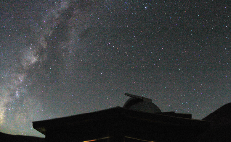
Jododaira’s Starry Sky
Jododaira offers ideal conditions for stargazing because the mountains encircling the area block out light from nearby towns and cities. On most clear nights, some 6,000 stars, the moon, the Milky Way, and many planets are visible to the naked eye from this part of Bandai-Asahi National Park.
Jododaira Astronomical Observatory Astronomy enthusiasts can view the moon, planets, and stars through the Jododaira Astronomical Observatory’s powerful 40-centimeter Cassegrain reflector telescope. Nighttime observation sessions are held free of charge every Wednesday and Saturday from May to October. Special events are occasionally held when astronomical phenomena occur, such as meteor showers and eclipse -
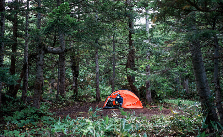
Jododaira Campground
At Usagidaira (1,576 m), visitors can stay at a popular campground approximately 1 kilometer from the Jododaira Visitor Center along the Bandai-Azuma Skyline. Jododaira Campground has tent sites, kitchen facilities with running water, and toilets. This wooded area is a convenient base for exploring the Jododaira area and hiking Mt. Higashi-Azuma and Mt. Issaikyo.
-
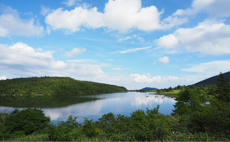
Kamanuma Pond
The curved shape of the pond, which resembles the blade of a sickle (kama), gives the pond its name. It is approximately 1,000 meters in diameter and 6 meters deep, and is flanked by the Sugadaira and Ubagahara Wetlands, with Mt. Issaikyo to the north. The pond can be reached via a 5-kilometer loop trail from the Jododaira Visitor Center (2 hours round-trip).
-
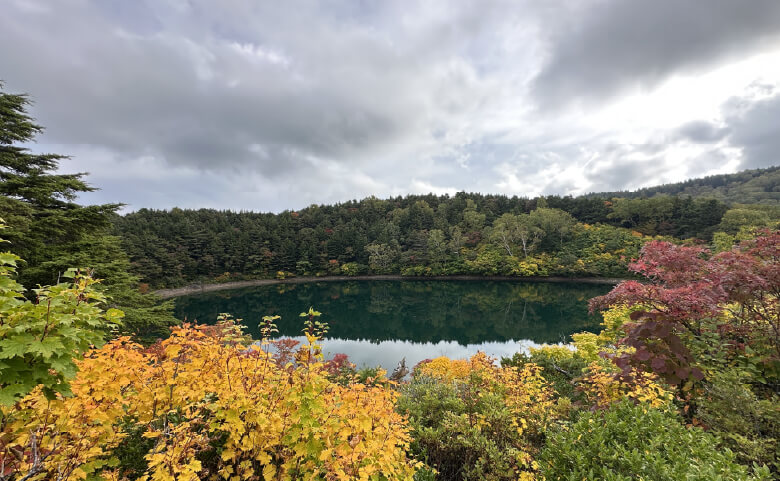
Okenuma Pond
Okenuma (1,595 m) fills the crater of an ancient stratovolcano and is surrounded by a thick deciduous forest. It has a diameter of around 150 meters and a depth of 13 meters.
The pond’s deep blue color contrasts with the surrounding greenery in spring and summer, and colorful foliage in autumn. Light-pink clusters of the rare Nemoto rhododendron, native to the region, bloom along the trail to Okenuma from June to July.